Hawk Ridge Snively Loop
On November 22, 2022, Cash and I made a loop out of a hike along Hawk Ridge by coming back on the Snively Trail (via Colby Rd). This was a nice hike in the “middle” of the city. We did not take any pictures.
Walk-Specific Map
Take Note
- Click on a segment to get specific information.
- Numeric labels correspond to the same labels in the elevation profile and summary information below.
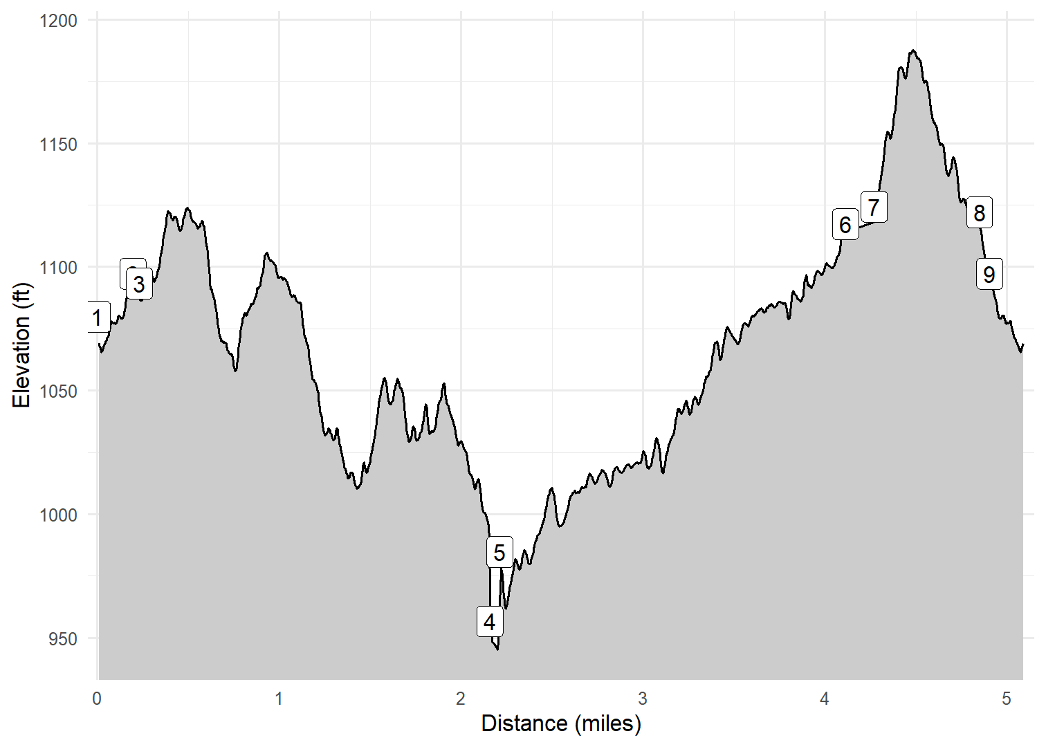
Elevation Profile
GPX Download
A sanitized GPX file of our hike is here.
Summary Information
| NUM | trackID | Primary | Description | Type | Distance | CumDist | DeltaElev |
|---|---|---|---|---|---|---|---|
| 1 | HWKRDG91 | E Skyline Pkwy | E Skyline Pkwy parking area to Cutoff to E Skyline Pkwy | Paved | 0.20 | 0.20 | 17 |
| 2 | HWKRDG92 | E Skyline Pkwy | Cutoff to E Skyline Pkwy to Hawk Ridge Tr | Paved | 0.04 | 0.23 | -4 |
| 3 | HWKRDG03 | Hawk Ridge Trail (Duluth Traverse) | E Skyline Pkwy to Amity West Tr | Trail | 1.93 | 2.16 | -97 |
| 4 | HWKRDG04 | Hawk Ridge Trail (Duluth Traverse) | Amity West Tr to Snively Tr | Trail | 0.05 | 2.21 | -9 |
| 5 | SNIVLY01 | Snively Tr | Hawk Ridge Tr to Colby Ave | Trail | 1.90 | 4.11 | 133 |
| 6 | CLBYAV01 | Colby Ave | Snively Tr to Hawk Ridge Tr | Paved | 0.16 | 4.27 | 7 |
| 7 | HWKRDG01 | Hawk Ridge Trail (Duluth Traverse) | Colby Ave to Cutoff to E Skyline Pkwy | Trail | 0.58 | 4.85 | -2 |
| 8 | HWKRDG93 | Cutoff to E Skyline Pkwy | Hawk Ridge Tr to E Skyline Pkwy | Trail | 0.06 | 4.90 | -25 |
| 9 | HWKRDG91 | E Skyline Pkwy | Cutoff to E Skyline Pkwy to E Skyline Pkwy parking area | Paved | 0.20 | 5.10 | -17 |